We couldn’t come to Alaska and not see
the Pipeline. It was built between 1974 and 1977. It begins in Prudhoe Bay and
extends thru some of the harshest lands know to man (and a few caribou).
And by the way, for those of you who are
wondering what the difference between a caribou and a reindeer are, you are
wondering aren’t you? I will try to
explain the confusing truth. Caribou are
reindeer in the wild. Reindeer are the domesticated
version of the caribou. I think that Santa
had something to do with that. Anyway
there is a population of approx 1,000,000 caribou that roam the tundra. Have we
seen one of the vast herds on our travels thru Alaska, the answer to that would
be no. Sharon got a glimpse of a few
when we took off from Deadhorse the other day (at least she tried to convince
me they were caribou) looked more like Bigfoot to me.
 When you see the Pipeline, it is truly
an engineering marvel. It winds through
800 miles of tundra and permafrost, mountains and forests, from Prudhoe Bay to
the Port of Valdez (that’s Valdeeeze if you don’t want the locals to know you’re
from someplace other than Alaska). Just
north of Fairbanks is an area where you can get up close and personal with the
pipeline. It is very interesting to read
about the engineering challenges that were overcome to accomplish this feat.
The pipeline goes under ground where the
land is stable enough to support it and not affect the permafrost and above
ground when needed to avoid the unstable areas. Don’t know where to put this in, but
permafrost has about 5-6 inches of squishy, mossy soil over frozen, icy soil
underneath. It melts when heated in any way and becomes a
thick, muddy glop. When they were
building the Alaska Highway they had to deal with it, the road crews still do
today. Even some of the newer homes in
Barrow were built on stilts for the same reason. Same thing would happen with the heat the
pipeline creates.
The Pipeline goes over 3 faults that are
subject to earthquakes and you can see how they zig-zagged the pipeline to
prevent the line from breaking apart in the event that would happen. It is very
interesting to see. I would suggest that
you look it up in Wikipedia if you are truly interested.
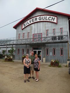
After lunch at another DDD brewery, the
Silver Gulch, Bob headed to the golf course to play with fun folks we’ve met
from North Dakota and Don, Joy and Sharon headed up the Dalton Highway.

If you've ever seen Ice Road Truckers, this is the beginning of that road. It is dirt and a little gravel, no hard surface. Even though it is only 250 miles to Coldfoot, it can take up to 10 hours to get there!!! And that's only half way to Prudhoe Bay when the real ice road begins.
By the way, when we were up in Barrow,
we heard a little secret. They are planning to develop another pipeline from
Barrow to Prudhoe Bay. This will cover about 350 miles and it will take about
10 years to develop. So those of you who
want to protest this potential environmental challenge you got plenty of time
to get with the program, but don’t expect the caribou and other creatures of
the north to jump on the band wagon. They love the pipeline it keeps them warm
in the winter. It gives them something to rub up against because there are not
any trees in that part of Alaska. That’s my story and I’m sticking to it.


No comments:
Post a Comment